Destination Run: Hyeres, France
May 04, 2026
 0
0
 Destination Run: Hyeres, France www.runnerclick.com
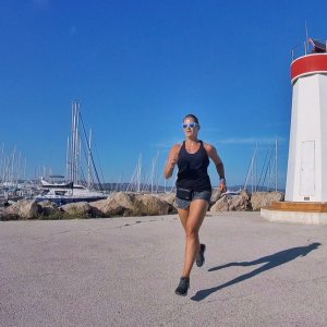
 Thinking about the south of France, the first few things that come to one’s mind are usually the beaches, wine, and relaxation. The last thing that pops up is finding a nice place for a good, long, training endurance run. However, summer fun does not allow for fall marathon training to be put on pause so it is always a good idea to be ahead of the game and research your travel destinations for running paths that can save you during your vacation and fall marathon prepping.
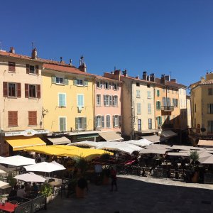
In the south-east part of France near the Cote D’Azur along the French Riviera, one may find themselves in Nice, Cannes, St. Tropez, or Marseille amongst many other beautiful cities and villages. Hyeres is a lesser-known city, but no less amazing, for fantastic cliffs, beaches and harbor views along the Balearic Sea. If you have the opportunity to visit this fantastic area, it is worth taking a run-tour through it as well.
We have provided you with two totally different running routes for Hyeres, France, both equally unique and challenging.
The Old Town (Click here for the map to this route)
The Old Town route will take you through, yes, the old town of Hyeres. Historically speaking, Hyeres is the oldest resort town on the French Riviera, however, the center of the city lies 4 kilometers away from the sea. This 4.2 mile/6.7 kilometer run is definitely a hilly challenge while at the same time this running route can also be described as historical and quaint. Beginning at Park Olbius Riquier, you will take a nice loop around the park before hitting the main road of Avenue Ambroise Thomas which you follow until you reach the Casino on your right.
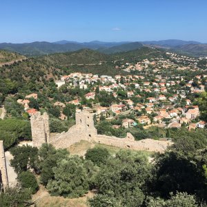
Take a right onto Avenue Jean Jaures, follow this until you see a driving school on your left and take that left to a rotary, keeping to the left onto Avenue Alphonse Denis. Take this road all the way to the city center and take a right onto a steep uphill on Avenue Gambetta, which at the top will lead you to Tour des Templiers, a clock tower, and plaza that is bustling with hungry tourists and restaurants. Here is where the tough part of the run comes in as we begin to make our way up to the top of the hill to the ruined castle. Going around the plaza turn left onto Place Massillon and start to weave in and out of narrow roadways amongst local residents, all uphill of course, until you reach Jardin Remarquable. It is a remarkable first vantage viewpoint overlooking old town Hyeres and catching a glimpse of the Mediterranean. After taking in some of the views, you will realize you have not reached the top yet.
Continue on the uphill trek on Sentier Saint Pierre until you reach the Chateau D’Hyeres. Feel free to climb up the stairs to the observatory to catch a view of the castle remains and all of Hyeres, the coastline, all the way out to the sea. The fun part about going up is that you have to come back down. Taking a nature trail through the castle remains will lead us back to the narrow roadways and home to the local residents. Taking Rue Saint Paul brings you back towards the clock tower. From there we retrace our steps back down Avenue Gambetta, downhill this time, until a left onto Avenue Joseph Clotis and a quick right onto Avenue Ambroise Thomas again to finish back at Park Olbius Riquier.
The Coastal View (Click here for the map to this route)
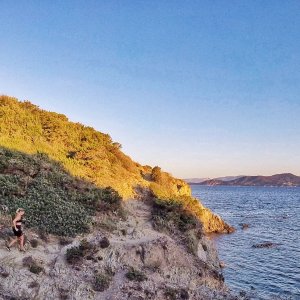
This long run of 12.39 miles, or just under 20 kilometers, will take you through some of the most beautiful coastal sceneries along with some difficult cliff walks and rough terrain, but if you are not privy to rushing through this run, it will all be worth it. Beginning and ending at Magic World Amusement park, start left onto Route des Marais until you reach a rotary and continue right onto Route de Giens. Unfortunately, there is nothing spectacular on this straight busy street that you will remain straight on for a little over a mile and a half until you get to a rotary where you will see signs for campgrounds for Presqu’ile de Giens.
However, be patient as the best is yet to come. Take a right onto Route de la Madrague and follow the bike path parallel to the sea until you reach about 5.5 miles in. The tricky part here is to find the next right which is a dirt path that looks like it leads to a summer home across the street from a small parking lot. This path will bring us to the start of the cliff walk trail called Lotissement l’Hermitage Giens. This breathtaking trail is narrow and challenging but provides spectacular views. You will follow the trail until you reach Point du Vue l’Ile Longue where you can outlook to several small islands.
To start to make our trek back, continue along a dirt path that will bring you back to a concrete road to eventually pass Campground Olbia. Keep going on Avenue Rene de Knyff which will bring you back to the road parallel to the sea to get back to the bike path. When you get to the end of the road, take a left onto Route du Sel instead of the original way we came to go between a marsh and the sea where you will find a lot of kite surfers and beachgoers along Plage de l’Almanarre. Follow to the end until you reach a rotary and take the first right to head back to Magic World.
Hyeres is a beautiful mix of history and nature and should be on everyone’s South of France bucket-list!
Latest Articles
 Is Running on a Treadmill Easier Than Running Outside?Runners have their own preferences, whether it is treadmill running, running outside on the road, or exploring trails. So...
 Is It OK to Use Trail Running Shoes on the Road?While trail running shoes can be used on roads, especially in situations where a runner encounters mixed terrains or pref...
 How to Fix Sore Quads After Running?Rest, ice, gentle stretching, and over-the-counter pain relievers can help soothe sore quads after running. Also, ensure ...
 10 Fruits With The Most Electrolytes to Replace Sports DrinksThese fruits are high in electrolytes such as potassium, magnesium, and calcium, essential for hydration, muscle function...